
Funding: $226.2 million, jointly funded by the Australian and ACT governments
Current update
- Walk across the new bridge at a free community open day on Saturday 5 December 2026. Plan your visit and register for the bridge walk.
- After the event, crews will finish work on the road and shared paths.
- Temporary overnight closures will allow safe completion of asphalt and kerb works where the new road alignment joins the existing sections of Coppins Crossing Road.
- The overnight schedule will help reduce disruption during busy travel periods.
- Further minor traffic changes may occur before the Molonglo River Bridge opens to traffic in early 2027.
Travel impacts
Coppins Crossing Road
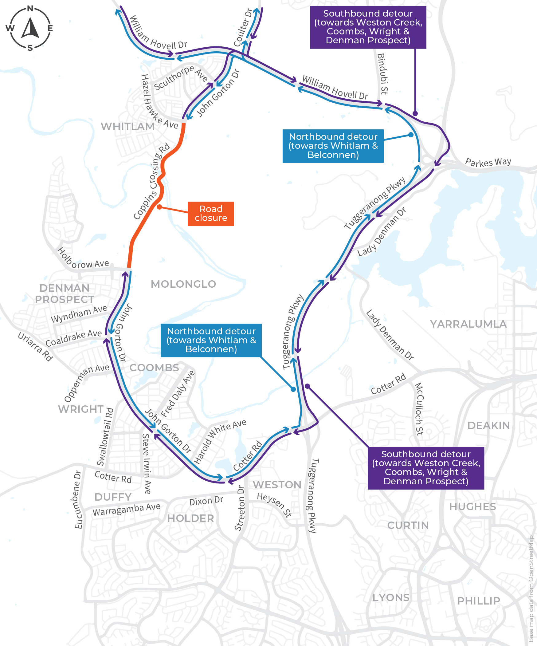
- Coppins Crossing Road between Holborow Avenue and Hazel Hawke Avenue have some temporary closures coming up:
- 6:00pm on Sunday 22 November to 6:00am on Monday 23 November
- 6:00pm on Monday 23 November to 6:00am on Tuesday 24 November.
- A contingency closure has been set aside for 6:00pm Tuesday 24 November to 6:00am Wednesday 25 November. This will only be used if weather or other unforeseen conditions delay the works.
- View the detour map.
Check the Travel Impacts page for more updates in this region.
Overview
The Molonglo River Bridge will connect Whitlam and Denman Prospect on either side of the river. The bridge and its approach roads will complete this section of John Gorton Drive.
The new road connection will support the release of land for development across the Molonglo Valley. It will also support the development of the future Molonglo Town Centre.
After the project is complete, the ACT Government plans to keep Coppins Crossing for maintenance access only.
Access to Namarag (Molonglo River Reserve)
Namarag (Molonglo River Reserve) is now accessed via Thancoupie Crescent, Whitlam. The former carpark and access trail from John Gorton Drive have been permanently closed.
The 70-metre walk from the new carpark emerges near the nature play space and lookout. The carpark and track are open but works will continue around the access track.
Community benefits
- A safer, more reliable river crossing during severe weather and floods.
- More reliable access to local services for people living in Canberra’s west.
- More options to walk, cycle or catch a bus across the river.
Project features
- A 200-metre-long Molonglo River Bridge (20 metres high) and approximately 1.7 kilometres of arterial approach roads (1 kilometre to the south and the rest to the north). It will be one of the longest weathering steel bridge in Australia and the tallest road bridge in Canberra.
- Public transport infrastructure including two queue-jump bus lanes and planning for future light rail infrastructure.
- Off-road paths to support the active travel network and provide access to the Molonglo River Reserve.
- Integration with the Molonglo Town Centre south of the bridge. This includes a pedestrian underpass of John Gorton Drive adjacent to the Molonglo Town Centre.
- Incorporation of a services corridor, including electricity, across the Molonglo River. This will allow the full development of Molonglo and Denman Prospect.
- Two new intersections including one connecting to the Molonglo Town Centre.
- Planned habitat for native fauna such as platypus nesting sites, pink-tailed worm lizards, water birds and bats.
The Molonglo River Bridge is part of the 'family of bridges' which also includes the pedestrian bridge, Butters Bridge.
Reports and publications
Stay up to date
- Subscribe to receive updates on the project
- Email the project team at InfrastructureCanberra@act.gov.au
Images
Project timeline
-
-
Community Engagement
-
Under Construction
-
Expected Project Completion
January 2027